|
There are Three Option for Nanadevi outter Trekking ::--> Kuaripass North Face 4 days trek ::---> Kuaripass Nanda devi Auli to Ghat Trek ::--->> Nandadevi Alpine Trek
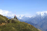
There are two versions of the Kuari Pass trek � a 6-day trek from Ghat village or a 4-day trek starting at Auli, the ski station just above Joshimath. The 6-day trek combines sleeping in villages with camping and goes over the pass at 3,400 meters, finishing in Tapovan or Auli. The 4-day trek is 3 nights of camping and you reach the pass at 3,600 meters, usually coming back down to Dhak village. We did the 4-day version, mainly because we weren�t able to put together a group and the price for just the two of us was too high for us swing the extra two days.
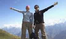
No matter which trek you choose, you�ll have fantastic views, walking through meadows, forest, and mountain trails. The trek itself is very accessible. We hike regularly (though not at any significant altitude) and found it very easy, a little light even. Any trekking company or guide will be able to break the trek down into shorter legs and more days if you have physical limitations. Our guide had recently done the 4-day trek in 8 days with an elderly Danish couple who had no experience trekking or hiking.
|
Location |
To the west of the Nanda Devi Sanctuary, Chamoli District, Garhwal |
|
Access |
Can be approached from either Tapovan via Khulara, or Joshimath via Auli, Gurson and Chitrakantha or from Ghat via Ramni. Both Ghat and Joshimath are accessible from Rishikesh by the Badrinath - Hemkund National Highway.Joshimath is the closest urban agglomeration in the region. |
|
Length |
Ranges from: 80km (Joshimath - Kuari Pass - Joshimath) to 78km (Tapovan - Kuari Pass - Tapovan) to 100km (Ghat - Ramni - Jhenjipatni - Panarani - Domabhiti - Kuari Pass - return) |
|
Duration |
Ranges from 8-12days to the Pass (the Joshimath � Auli - Kuari Pass route can also be traversed in 4 days) |
|
Altitude |
3640m ::-->> Pangarchulla peak 4575 meter |
|
Type |
Summer & Winter trek |
|
Season |
April - October (May to June and mid September to November) |
|
Difficulty and grading |
Grade II Soft |
|
Brief description |
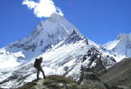
The Kuari Pass (Khal), also known as the Curzon Trail/Pass, lies to the west of the Nanda Devi Sanctuary and has an imposing view of the Garhwal Himalayas. Popularised by Lord Curzon when he was Viceroy of India, the Kuari Pass route to Joshimath was one of the treks he undertook in the Garhwal Himalayas. The twin peaks of the Nanda Devi, Dunagiri Bethartoli and the Devathan are peaks that are visible from the Pass in clear weather. Enroute, there are spectacular views of the Kedarnath, Kamet, Neelkanth, Rishikot, Changabang and Chaukhamba peaks. The trek itself traverses three passes, through dense forests of oak, pine, rhododendron and fir and through wide-open meadows called bugyals (including the Gurson Bugyal). These bugyals are typical to the region and act as high altitude summer grazing grounds for the village�s enroute. The Kuari Pass itself is just a small col in a grassy ridge. Looking south from the pass, there are impressive views over the forest ridges and the small clearing at Dakwani is also spectacular. The ascent is difficult and steep in parts. The Ghat route is the more favoured route for trekkers. It is the longest and has some of the more spectacular views. The Curzon Trail is one of the better-marked trekking routes in the region with directions and distances marked on old milestones carved out of stone and located strategically along the route. The route description for the Joshimath to Kuari Pass section are placed below
Day 1 - Joshimath � Chitraganta (Average walking time 6 to 7 hours) From Joshimath a jeep can be hired for a 12km drive to Auli. Alternatively, the distance can be trekked. It encompasses a 2-3 hour trek rising 900m through forestland. Auli is a small settlement, which recently has developed into a thriving ski resort.
From Auli, the distinctive summit profile of Nanda Devi can be appreciated at the head of the sanctuary. The trail from Auli heads up the hillside beyond the ski lift, before reaching a small oak and holly forest. Through the forest, the trail passes a small temple before emerging at the base of an extensive series of meadows known as the Gurson Bugyal. The shepherd trails are at times hard to follow but the local shepherds are helpful. There are a number of vantage points to appreciate the classic route up the Rishi Ganga into the Nanda Devi Sanctuary, and the trail via Lata and Lata Kharak to the Durashi Pass (4,260m) can be appreciated from the far side of the valley.
The trail beyond Gurson Bugyal is steep in places, before an ascent over and around a rocky outcrop to a small lake along a well-constructed trail coming from the Tapovan village. From the lake, the trail continues through a mixed pine and oak forest for 2-3km before a short descent to the meadow at Chitraganta (3,310m). From the meadow, the snow-capped ridge, including Chaukhamba I (7,138m), II (7,068m), III (6,974m) and IV (6,854m) can be seen beyond Joshimath. Camping sites abound in the valley.
Day 2: Chitraganta to Kuari Pass (Average walking time 4 to 5 hours) The trail ascends the ridge above Chitraganta. Some cairns mark the track, which is at present being upgraded by the villagers from Tapovan. Just below the pass, the trail leads through a meadow affording spectacular views of the Himalayan and Zanskar ranges. North of Joshimath is the Chaukhamba Range, Neelkanth (6,596m) and Narayan Parbat (5,965m) while the peaks of the Zanskar range including Mana Peak (7,272m), Kamet (7,756m) and Abl Gamin (7,355m) extend to the Tibet border. In the middle foreground, the main Himalayan chain in the vicinity of the Bhuyandar Valley and Hemkund includes Nilgiri Parbat (6,474m), Ghori Parbat (6,708m) and Hathi Parbat (6,727m). Dunagiri (7,066) dominates the peaks to the north of the Nanda Devi Sanctuary, which also include Changabang and Kalanka. There are many campsites nearby and a short stage from Chitraganta could be combined with a trek along the adjoining ridge that heads towards the Nanda Devi Sanctuary. Here there are possible vantage points to view Nanda Devi�s distinctive profile including the twin peaks of the main summit and the east summit.
|
|
Awareness / popularity |
Kuari Pass, due to its proximity to Auli as well as Joshimath, is one of the more popular treks in the region. However, due to the longer duration of the preferred Ghat route, the trek does not attract as many visitors as the Har ki Dun and Pindari treks. |
|
Logistical support |
All logistics including porter and mule hire is from Joshimath and Ghat. Joshimath was once a thriving town for trekkers and expeditions requiring staff and porters before entering the Nanda Devi Sanctuary. However, with the closing of the Sanctuary in 1983, activity in the town has subsided considerably. Ghat is a smaller town and less organized than Joshimath. While basic foodstuff can be acquired at Joshimath, processed food needs to be procured at Delhi or Dehradun. |
|
Local authority assistance |
Apart from the staff at the GMVN guesthouses at Auli, there is little governmental assistance in the region. The Forest rangers are helpful and can be approached for assistance. |
|
Infrastructure |
Location Accommodation Eating facilities Ghat FRH, V D Ramni V, N.A. N.A. Jhenjipatni V, N.A. Panarani V, N.A. Domabhiti V, N.A. Kuari Pass N.A. Tapovan C, N.A. D Auli TB, H, C D, R Joshimath TB, H D, R |
|
Signage |
Not available except as painted signs on rocks during the trekking season. These signs are generally painted onto the path by trekkers / trekking associations. |
Tour program from Ghat to Auli :: Lord Curzon Trail with Nandadevi View Trek ::
DAY 01 : DELHI TO HARIDWAR (292M) BY TRAIN - RISHIKASH (334M) BY ROAD 1 HRS
Early Morning Transfer to railway station to take Morning train 6.30 AM.
Departure from Delhi Arrival Haridwar 11.30 AM. Transfer by car 1 H to Rishikash,
Evening for Arti Ceremony witness at tribune Ghat Ganga simmering with burning
lamps and echoing prayers. Overnight stay and food at hotel Neeraj Bhawan
DAY 02: HARIDWAR TO
GHAT (579M) 125 KM BY ROAD (OUR SERVICE FROM HARIDWAR TO HARIDWAR)
Morning after brekfast drive to Ghat by road 10 hrs. On the way cross Devaparyag
holy confluences of the various tributaries of Ganga. : Deoprayag is the Most
sacred of all the prayags because it's the very first one at the confluence of
Bhagirathi (originating at Gaumukh) and Alaknanda (originating from snowy peaks
above Badrinath). The two become the Ganges, then after drive to Srinagar.
Overnight food and stay in Camp
DAY 03: GHAT TO GOHNI
(2550M) 1ST DAY TREK09 KM TREK
Morning after breakfast the trek starts with packed lunch 1st day to Gohni -
Gradual trek walk 6 hrs through Deodar forest and Bhotias villages leaving
behind the Nandakini river. An ethnic school near village of Gohni is very
interesting. Overnight food and stay in Camp
DAY 04: GHONI - RAMNI
TO JHENJIPANI (1524M) - 13 KMS TREK - 5 TO 6 HRS
Morning after breakfast the trek starts with packed lunch An ascend of about 3
hrs and a gradual descend of 2 hrs through a quiet forest and a local settlement
en route. The locals here are a unique race of Brahmins, as they have never
ventured beyond the mountains ever into the towns. Overnight food and stay in
Camp.
DAY 05: JHENJIPANI TO
PANA RANI (2043M) - 12 KMS TREK - 7 HRS
Morning after breakfast the trek starts with packed lunch A 4 hrs trek ascending
steeply for about 3 hrs followed by descend into the village of Pana. The route
follows the valley and this village of Pana contains the Garhwali community
known for their expertise in sheep wool weaving activities. They only ever use
homespun clothes. Evening for rendezvous with the locals. Overnight food and
stay in Camp.
DAY 06: PANA RANI TO
DOMABHITI (2296M) - 10 KMS TREK � 6 HRS
Morning after breakfast the trek starts with packed lunch Trek 6 hrs gradually
ascending through thick forests containing a rich variety of flora and fauna.
Numerous herbs are found in this area and the locals are known to pick them for
local use. Nomads grazing their sheep's en route is indeed interesting encounter
as they lead a totally contrasting life-style. Overnight stay and food in Camp
DAY 07: DOMABHITI TO
KULARA (3100M) - VIA KUARI PASS (3640M) - 10 KMS TREK - 4 HRS
Morning after breakfast the trek starts with packed lunch to Pangarchula Base
camp, 1 hrs trek from Domabhiti to Kuari Pass. Kuari Pass at 3640m the view from
the summit will more than compensate for any difficult on the trail. Almost the
whole of Garhwal Himalayas is in view- the great Badrinath groups of peaks to
the north and to the west the Nanda Devi sanctuary; Dunagiri (6489m);
Bethartholi (6352m); Hathi Parvat (6727m), Kamet (7756m), Nilkanth; Manna and
Trishul are among the peaks we expect to see. From Kuari Pass you will not see
the most impressive Mt. Nanda Devi (7820m.) at the stone through distance. After
continue 2 hrs trek to Kulara Base camp then you will see Nanda Devi peak,
Overnight food and stay in Camp
DAY 08: KULARA TO
AULI (2750M) - 16 KMS. TREK
Morning after breakfast, trek 5 hrs to reach Auli today last day of trek - a
winter ski resort, at the height of 2700m. Auli provides excellent opportunities
for cross country, slalom and downhill skiing events. It offers a 180o panoramic
view of Nanda Devi (7820m), Kamet (7756m), Mana Parvat (7273m), Dunagiri
(6489m), Bethartoli (6352m), Neelkanth (6596m), Hathi (6727m) and Ghori Parvat
(6590m). After drive to Joshimath 1hrs, Overnight food and stay in hotel
DAY 09: JOSHIMATH TO
HARIDWAR
Morning After breakfast drive to Haridwar by car or bus in 10 hrs. Overnight
food and stay in hotel
GENERAL CLOTHING LIST
Jacket in Gore-Tax, Jacket in polar, Trouser of trekking, Trekking shoes,
Slippers, Light Rain Suit, T-shirts, Full sleeves sweater, Gloves, Sun glasses,
Woolen socks, P-Cap and Woolen Cap, Towel, Toothbrush & Paste, Soap
EQUIPMENT
Sleeping bag � 15 degree C minimum, Day pack, Water bottle, Toilet paper, Torch
and batteries, Pocket knife, Pair of walking stick
PHOTOGRAPHIC OPTIONAL
Camera, Spare batteries, Film, Binoculars
FIRST AID MEDICAL
Personal medication, Sun protection cream, Insect repellent, Lip guard,
Antiseptic cream, Bandages, Throat lozenges
The Auli-Kuari pass trekking trip provided by us includes duration of seven
Days. The travel services provided by us are designed keeping in mind the
budgetary constraints of various clients and can also be customized as per their
requirements.
THE ITINERARY OF OUR JOURNEY IS SPECIFIED BELOW:
ITINERARY (EX: RISHIKESH) - DURATION: 05 NIGHTS / 06 DAYS
Day 01 : Drive 260kms to Joshimath and then to Auli with lunch enroute. Dinner
and night stay in Auli
Day 02 : 14 kms trek
to Tali via Gurson with packed lunch Dinner and night stay in camp
Day 03 : 09 kms
trek to Bagarbudda/Khulara with packed lunch Dinner and night stay in camp Kwari
pass
Day 04 : Trek to Kuari pass 04 kms with packed lunch In the evening, trek back
to Khulara Dinner and night stay in camp
Day 05 : 14 kms
trek to Tapovan with packed lunch Further 14 kms drive to Joshimath Dinner and
night stay in hotel
Day 06 : 256 kms drive to Rishikesh Arrive Rishikesh and thus the tour concludes
For Further Details and Booking write down us or call us :
Corporate Office![]()
( A Unit of Adventure Trekking)
24 HRS contact number : + 91-
09837937948 / 09759675791
/ 09412439693
Email: nandadevitrekking@gmail.com
CHAT RD : MSN : YAHOO : SKYPE : garhwalhimalaya
Visit us: www.valleyofflowerstrek.in / www.nandadevitrek.in
![]()